

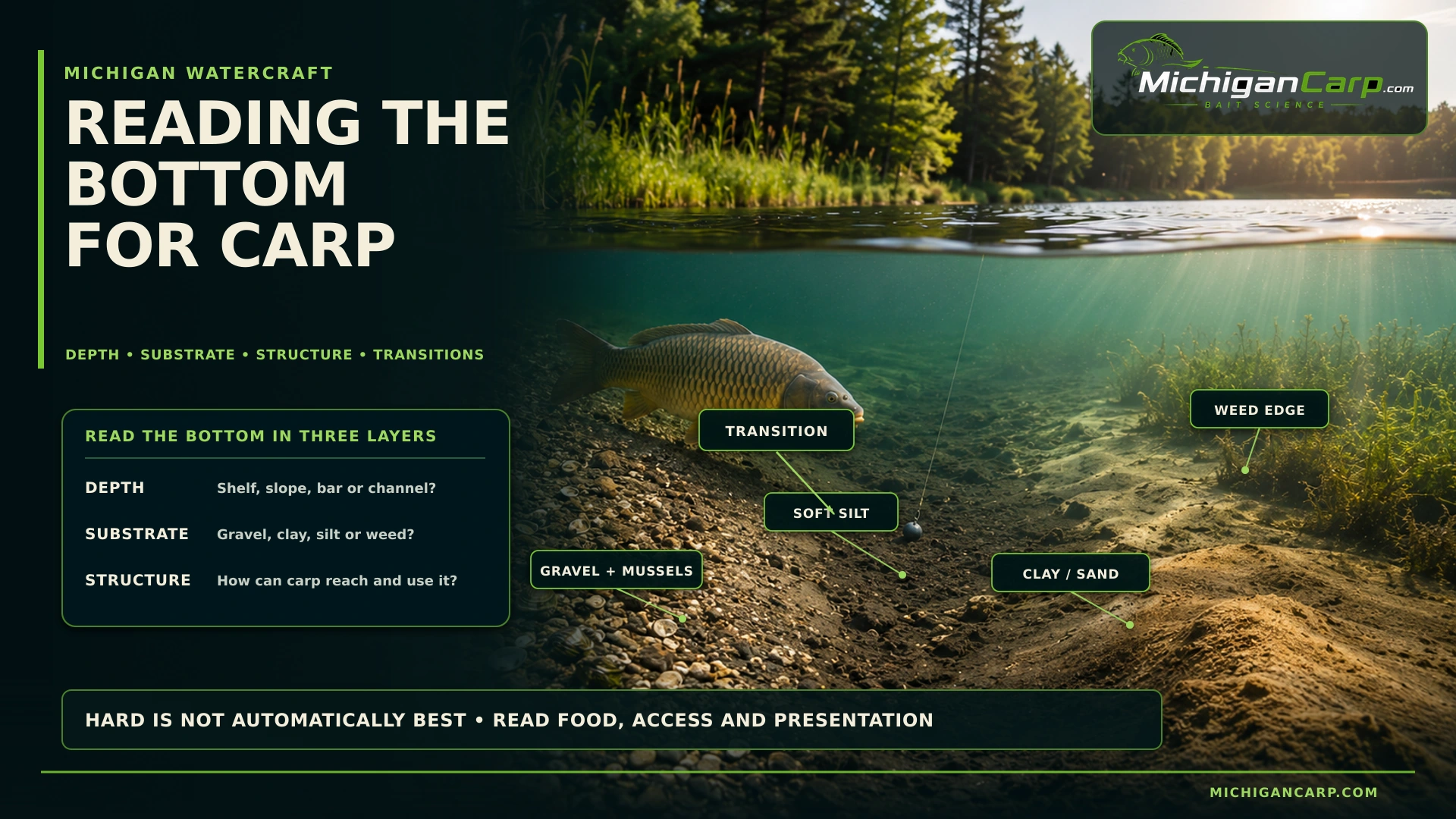
Reading the bottom for carp is not a search for the hardest patch you can find. It is a way to understand what lies beneath the rig, how the depth changes, where one bottom type becomes another and whether carp have a reason to use that exact area. A firm gravel spot can be excellent. So can a soft food-rich strip of silt. A clean sand shelf can be a route. A mussel-covered ledge can hold food but threaten line. The bottom only becomes useful when substrate, depth, structure, access, presentation and fish evidence agree.
This guide gives you a repeatable bank-side method. It explains how to use maps, a bare lead, a marker float, sonar, shoreline clues and careful notes without pretending any one signal provides certainty. It also separates established carp biology from angling interpretation. The science confirms that common carp consume benthic organisms and organic material and can disturb sediment deeply while foraging. It does not prove that every firm “donk,” sweet-smelling silt patch or polished gravel area is a productive carp spot.
For the bigger question of choosing the right part of the lake, begin with How to Find Carp in Lakes. This article takes over once you need to turn a promising area into a usable underwater map.
Read three things together: what the bottom is, how the depth changes and how carp can reach and use it. Hard bottom is information—not an automatic answer.
Table of Contents
Quick Answer: What Makes a Bottom Worth Fishing?
A bottom is worth fishing when it offers a believable combination of food, access and presentation. Start by asking what role the area plays. Is it a feeding surface, a patrol line, a route between shallow and deep water, a clean place beside weed, or simply a feature that feels satisfying through the rod? The last one is not enough.
| What You Find | What It May Offer | What Must Be Confirmed | First Fishing Decision |
|---|---|---|---|
| Firm patch inside softer ground | A clean presentation area and a clear transition | Carp signs, food or route value | Test the patch and its soft edge rather than assuming the center is best |
| Soft silt beside weed | Detritus, insect larvae, snails and a natural browsing area | Silt depth, rig presentation and safe landing | Use a suitable light or elevated presentation; do not abandon it because it is soft |
| Sand or clay shelf | A clean route, depth change or resting area | Whether fish actually cross or feed there | Fish the route or edge; clean does not necessarily mean food-rich |
| Gravel, rock or mussel seam | Hard structure, natural food and a defined line | Abrasion, snag risk and fish-safe line angle | Strengthen protection or choose the safer edge |
| Bar, channel or drop-off | A depth connection and a repeatable travel line | Season, oxygen, temperature and direction of travel | Test top, slope and base instead of treating the feature as one spot |
| Clear hole in weed | A fishable opening inside food and cover | Whether it is genuinely clear and large enough to land fish safely | Present accurately and use tackle capable of controlling fish |
| Beautiful hard spot with no signs | Easy casting and neat rig placement | Any reason for carp to visit | Keep searching; a castable spot is not automatically a carp spot |
The useful sequence is simple: identify the area, map the change, confirm fish use, then select the presentation. Reversing that sequence is how anglers end up fishing an immaculate rig in empty water.
Read Three Layers Together: Depth, Substrate and Structure
“The bottom” is not one variable. It is a three-layer picture. Substrate describes the material touching the lead. Depth describes its vertical position. Structure describes the shape and connection that can organize movement. A gravel patch at the base of a drop-off is not the same fishing proposition as identical gravel on an isolated flat.
| Layer | Questions to Ask | What the Answer Changes |
|---|---|---|
| Depth | How deep is it? Does depth rise, fall or stay level? Is the measurement current? | Seasonal comfort, line angle, light, access and where food may collect |
| Substrate | Is it firm, soft, weedy, shelly, rocky or covered with debris? How uniform is it? | Rig behavior, lead penetration, abrasion and natural-food possibilities |
| Structure | Is it a shelf, bar, slope, channel, point, hole, edge or open flat? | Routes, holding positions, approach angles and repeatability |
| Transition | Where does one depth or substrate become another? | Precise edges to test and a reliable reference for recasting |
| Fish use | Are carp feeding, showing, lining up or repeatedly passing? | Whether the mapped feature deserves a rod at all |
Substrate Tells You What the Rig Meets
Gravel, sand, clay, silt, shell, weed and leaf litter each change the way a lead lands and a hookbait settles. They can also support different food communities. Yet a substrate label is only a starting point. “Silt” can mean a light film over firm ground, deep loose organic material, compacted mud or a mixed layer full of plant fragments. “Gravel” can mean clean pea gravel, larger stone, shell-covered rubble or a thin hard crust over softer material.
Depth Tells You Where the Substrate Sits
Depth affects light, temperature, pressure, line angle and the relationship between feeding water and safer water. It also changes the strength of information reaching the rod. A lead falling through five feet of calm water is easier to interpret than the same lead falling thirty feet at range in crosswind. For a seasonal depth framework, use Best Depth for Carp Fishing.
Structure Tells You How the Area Connects
A channel edge can connect a shallow bay to the main basin. A bar can offer a top, two slopes and a food-collecting base. A point can narrow a travel route. A weed edge can run across several bottom types. Structure organizes the choices available to the fish; it does not guarantee that carp will use every part of it.
Transitions Give You a Precise Place to Test
A gradual change from sticky silt to firm clay, a sudden band of shell, the first clean pull beside weed or the crest of a slope is easier to recast to than an undefined “good area.” It also lets you compare two neighboring conditions without moving the whole swim.
Start Before Casting: Maps, Shoreline and Margin Clues
The cheapest cast is the one you do not need to make. Maps, shoreline geology, visible margins, exposed banks and satellite imagery can narrow the search before a lead repeatedly hits the water. They are planning tools, not final truth.
Use Michigan DNR Maps as a Starting Model
Michigan DNR provides inland-lake maps for roughly 2,700 of the state’s more than 11,000 inland lakes. The DNR also warns that those maps may not completely represent current conditions. Old soundings, changing water levels, sediment movement, weed growth, beaver activity, dam operation and shoreline work can all separate the chart from the water you face today. Use contours to form a hypothesis, then verify the fishable area.
For a full pre-trip workflow using public data, access information and satellite imagery, read How to Research New Carp Waters in Michigan.
Read the Shape of the Shoreline
A point visible above water may continue underwater, but not always at the same angle. A steep bank can suggest nearby depth, while a long marshy edge often suggests a shallower gradient and softer material. Wind exposure, inflows, outflows, reeds, docks and erosion lines add clues. Treat each as a probability, not a promise. Glacial lakes, dam ponds and drowned river systems can hide abrupt changes that the bank does not reveal.
Inspect the Margin Without Disturbing It
Polarized glasses and a quiet walk can reveal sand, clay, gravel, shell, snails, different weed types, leaf accumulation and small depth changes. Margin material may continue farther out, or it may end abruptly. The important point is to collect a first sample of the lake’s character before casting. Do not trample spawning habitat, wade where access rules prohibit it or stir the exact margin you intend to fish.
Use Exposed Material Carefully
Shells, gravel and clay on the bank can indicate local substrate, but wave action may have transported them. Mussel shells on shore show that mussels exist in the system, not that a productive live bed lies at your chosen range. Weed stranded after a wind can reveal species and seasonal dieback but not its exact underwater boundary. Shore clues narrow questions; the lead or electronics tests them.
Record Water Level With Every Map
A depth mark without water level can become misleading, especially on dam ponds and reservoirs. If the water drops three feet, yesterday’s twelve-foot shelf is now nine feet and a comfortable line angle may become a snag risk. Note a visible gauge, launch ramp reference, shoreline mark or published level when available.
How to Read the Bottom With a Lead
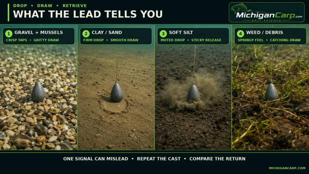
A bare marker lead can provide useful relative information from the bank. It cannot identify bottom composition with laboratory certainty. The aim is to build a repeatable comparison: use the same lead, rod, line, casting position, distance and retrieve speed, then combine the fall, the draw and anything that returns on the lead.
Use a Dedicated, Hook-Free Setup
Use a plain lead or marker lead with no hook, hooklink or bait. The setup should cast safely, transmit information and retrieve cleanly. Choose a weight appropriate to the rod, range, line, water depth and bottom. A lead heavy enough to transmit well can also bury deeply in silt, while an excessively light lead may give vague feedback. Consistency matters more than chasing one supposedly perfect shape.
Control the Fall Without Pulling the Lead Back Toward You
After the lead hits the surface, manage slack and follow the fall with the rod so you remain in contact. Too much slack erases the landing signal. Holding the line excessively tight can pendulum the lead back toward the bank, especially in deeper water, so it lands shallower than the cast’s original range. The best technique preserves enough contact to feel the touchdown without dragging the lead through the water column.
Let the Lead Settle Before the First Draw
Pause briefly after touchdown. Then lower the rod, tighten steadily and draw the lead a short controlled distance. A violent strike-like pull can tear the lead free, cut weed, jump stones or convert several subtle signals into one rough sensation. Use short repeatable draws, reset the rod position and compare.
Keep the Same Rod Angle and Retrieve Speed
Rod-tip height, stretch in mono, braid diameter, crosswind, range and current all change the message. Mapping with one setup reduces those variables. You do not need perfect sensitivity; you need a method that gives similar signals when the lead crosses the same line twice.
Limit Casts Once the Picture Is Clear
Repeated marker work can move or spook carp, especially in shallow or pressured water. Map the minimum needed to answer the question. If fish are already feeding, use visible signs and a quiet first presentation instead of repeatedly leading through them.
What the Drop, Draw and Retrieve Can Tell You
No single sensation proves the bottom type. A convincing interpretation uses three stages: drop, draw and retrieve. Conditions can weaken or imitate each signal, so the best description is usually “consistent with gravel” or “probably soft silt,” not “definitely gravel” after one cast.
| Possible Bottom | Touchdown | Controlled Draw | What May Return | Main Caution |
|---|---|---|---|---|
| Gravel, small stone or shell | Often a sharper, more distinct landing | Repeated tapping, scratching or chatter | Occasional shell fragment; usually little material | Rock size, shell and firm debris can feel similar |
| Firm clay or compact bottom | Distinct but sometimes duller than stone | Smooth, steady resistance with little chatter | A colored smear may cling to the lead | Firm silt or smooth sand can overlap |
| Sand | Moderate, clean touchdown | Smooth pull; resistance can increase with lead shape | Fine grains may cling when wet | Coarse sand and fine gravel are a continuum |
| Soft silt | Muted thud or weak landing signal | Initial suction, plugging or a heavy smooth pull | Dark or pale smear, fine sediment, organic fragments | Depth, wind and long-range mono can also mute the drop |
| Weed | Touchdown may feel cushioned or incomplete | Springy loading, grabbing, then release | Green strands, dying fragments or slime | Sparse weed over hard bottom can produce mixed signals |
| Leaves or chod | Soft, inconsistent landing | Light snagging, dragging or sudden releases | Leaves, twigs, fibers or decomposed material | Seasonal debris can sit over any substrate |
| Large rock or timber | Hard, abrupt or irregular contact | Stops, wedges or sharp directional changes | Little evidence; possible abrasion | Snag risk can make further mapping unsafe |
The Drop Is Relative, Not a Universal Sound
Anglers call a clear hard landing a “donk,” but the exact feel depends on far more than hardness. Water depth, lead weight, rod position, line stretch, wind and bottom slope all influence it. Compare adjacent casts with the same setup. A stronger touchdown on lane three than lane four is more useful than trying to match someone else’s description of the perfect donk.
The Draw Often Reveals the Change
The most useful moment may be when the lead leaves one material and enters another. Chatter that becomes smooth, suction that suddenly releases, weed that clears into a free draw or a heavy pull that becomes crisp can mark a transition. Note the exact distance and confirm it on another cast.
What Returns Is Evidence, Not a Complete Sample
Weed, leaves, clay smear or shell can strengthen the interpretation. A clean lead does not prove a clean bottom; many substrates do not cling to it. A foul smell can indicate reduced organic conditions, but it does not prove that the area contains no natural food or that carp never use it. Avoid turning one odor, color or strand into a biological verdict.
Countdown Gives Relative Depth Unless Calibrated
Counting from surface impact to touchdown can compare neighboring casts, but it is not automatically feet or meters. Sink rate changes with lead shape and weight, line drag, depth, current and how tightly you control the fall. Calibrate the same setup in a known depth or use a marker float if you need an actual measurement. Treat “six counts” as a repeatable relative index until calibrated.
Bottom-Type Guide: Gravel, Sand, Clay, Silt, Shells and Weed
Common carp are benthic feeders, and the bottom can provide detritus, insect larvae, small crustaceans, snails and other organisms. The U.S. Fish and Wildlife Service common-carp review summarizes adult diets that include organic detritus, chironomids, small crustaceans and gastropods. That supports a broad lesson: natural food is not restricted to clean gravel. It does not tell you which exact patch is productive today.
| Bottom or Cover | Potential Value | Presentation Question | Risk or Misreading |
|---|---|---|---|
| Gravel and stone | Clean surface, transitions, snails or attached mussels | Can a bottom bait sit and reset cleanly? | Hardness is easy to like even when food and fish are absent |
| Sand | Clean route, shelf, bar or shallow warming area | Will bait remain visible and stable? | Uniform clean sand may offer little reason for carp to stop |
| Clay | Firm smooth presentation and a clear edge beside softer ground | Is it bare clay or a thin coating over firmer ground? | Smooth firm clay can be mistaken for sand or compact silt |
| Silt | Detritus and benthic food; carp can forage deeply | How far will the lead and hookbait settle? | Soft does not mean bad, but deep silt can bury a poor setup |
| Zebra or quagga mussels | Hard structure and a biologically active edge | Can the line and leader survive contact? | Shells can create abrasion and snag hazards; species and density are hard to infer by feel |
| Living weed | Food, cover, shade and defined edges | Is there a safe hole, channel or edge? | The thickest weed may be unfishable or unsafe |
| Dying weed and leaf litter | Seasonal detritus and possible food | Can the hook remain exposed? | Debris can mask the hook and may coincide with poor local oxygen |
| Rock, timber or man-made debris | Edges, cover and travel lines | Can a hooked carp be controlled and landed? | An attractive feature is not worth avoidable fish loss |
Gravel Is Useful, Not Magical
Gravel often gives clean presentation and a distinct lead response. Carp may also visit stone and shell areas for food. But a bare gravel patch can be a route, a resting area, a cleaned feeding spot or an unproductive surface. Look for recent feeding signs, nearby silt, weed, depth change or a line that connects useful water.
Sand and Clay Can Be Excellent Routes
Smooth firm substrates are sometimes ignored because they do not feel dramatic. A sand tongue between weed beds, a clay shelf beside silt or a firm lane leading into a bay can be easier for carp to travel and easier to present on. Their value may come from position rather than the substrate’s own food production.
Mussel Areas Need an Abrasion Decision
Michigan’s zebra-mussel guidance notes that zebra mussels require hard substrates, while quagga mussels can attach to hard or soft substrates and much greater depths. A rough, shelly signal may identify a promising area, but it must also trigger a tackle and line-angle check. Do not fish directly across sharp structure with line that cannot tolerate contact. The safer side of the bed may catch just as well and land more fish.
Weed Is an Overlay and a Structure
Weed can grow over sand, silt, gravel or clay. That means “weedy” does not fully describe the bottom. The edge, density, species, health and underlying substrate all matter. Keep the detailed weed decisions inside the protected Weed Beds and Carp Fishing guide.
Soft Silt: Productive, Problematic or Simply Unknown?
Soft silt is one of the most misunderstood carp substrates. It can be a deep, awkward layer that swallows a heavy lead. It can also be a living food zone containing organic material and benthic invertebrates. The correct question is not “Is it soft?” but “How soft, how deep, what lies within or beside it, and can I present safely?”
Carp Can Work Well Below the Surface
A shallow Midwestern lake experiment measured sediment mixing to about 13.0 ± 3.7 centimeters in areas accessible to carp versus about 5.0 ± 1.2 centimeters inside carp exclosures. The Huser and colleagues sediment-mixing study was designed to examine lake ecology and phosphorus, not angling spots. Its useful limit here is clear: carp activity can disturb and mix more than a film on top of soft sediment. A bait lying on soft material is not automatically outside their feeding zone.
Do Not Call Silt Dead From One Smell
Dark color, gas bubbles or a sulfur-like odor can indicate decomposition and low-oxygen chemistry within sediment. They do not, by themselves, show that the overlying water lacks oxygen, that no invertebrates live nearby or that carp avoid the area. The most defensible field categories are practical: shallow or deep; loose or compact; clean enough or too fouled for the intended presentation; associated with fish evidence or not.
Estimate How Far the Lead Plugs In
A muted landing followed by strong initial suction suggests the lead entered the surface. Compare a lighter lead, a different shape or a shortened draw. If the lead repeatedly returns coated to the same point and takes force to release, assume the hookbait could also settle unless the presentation prevents it. You rarely need an exact sediment depth to make a good decision. You need to know whether the chosen rig remains exposed and safe.
Fish the Soft-to-Firm Change
The edge of deep silt can combine food with easier presentation. A gradual firming may be more valuable than a tiny clean patch in the center of nowhere. Confirm the boundary from two casting lanes, then choose the side that best matches fish signs and rig behavior.
Let Fish Evidence Overrule the Dinner-Plate Habit
If carp are fizzing, clouding and repeatedly returning to soft ground, forcing every rod onto the nearest hard patch may move the bait away from the food. Adapt the rig to the carp rather than requiring the carp to feed where the rig looks neatest.
Read Depth and Structure: Shelves, Bars, Slopes and Channels
Depth and structure turn bottom type into a route. The most useful map identifies the top, slope, base and neighboring flat—not merely a single depth number. The same bar can fish differently on its windward face, sheltered back, shallow crown and deep foot.
| Structure | Parts to Map | Possible Carp Use | Common Mistake |
|---|---|---|---|
| Shelf | Near edge, flat top, outer lip and drop | Feeding access with depth nearby | Fishing the center without checking either edge |
| Bar | Crown, both slopes, ends and bases | Patrol line, feeding strip or seasonal staging | Treating the entire bar as one spot |
| Point | Shallow spine, side slopes and tip | Narrows routes and reaches multiple depths | Assuming the visible shoreline angle continues unchanged |
| Channel | Both lips, floor, bends and mouths | Movement corridor, current line or winter/summer access | Fishing the deepest center by default |
| Drop-off | Break point, face and base | Fast access between feeding and holding water | Letting line rub the lip or lead roll down the slope |
| Plateau or hump | Top, first break and sheltered side | Isolated feeding or resting area | Overcasting and missing the near edge |
| Weed edge or hole | Inside edge, outside edge, opening and underlying bottom | Food, cover and a defined lane | Choosing the thickest cover without a landing plan |
| Uniform flat | Subtle depth, firmness, food and traffic changes | Broad feeding area or repeated route | Assuming “featureless” means unused |
Map the Crest and the Base
A sharp change in countdown followed by a different draw can mark a slope. Cast beyond it, identify the deeper touchdown, then retrieve slowly until resistance changes. Repeat from a neighboring angle. On a steep face, note where the lead finally rests; a rig that slides after casting may not remain where you first felt it land.
A Channel Is More Than the Deepest Line
Carp may use the lip, a bend, the mouth or the adjacent flat rather than the center. Current, food deposition and oxygen can change which part matters. In dam ponds and drowned river systems, old channel edges can also contain timber and abrupt snag risks.
A Flat Can Still Contain Important Micro-Changes
A one-foot depth change, a firmer strip, a sparse weed lane or a shell band may be more important than a dramatic far-bank feature. On large Michigan water, carp can feed over broad flats; the mapping job is to find the repeatable line inside that space, not to manufacture a spectacular feature.
Depth Must Stay Inside the Seasonal Picture
A shallow dark bottom can matter during spring warming. A shelf beside deeper water can become useful during summer or fall. A deep basin can be irrelevant if oxygen is poor. Use bottom mapping to describe the geometry, then connect it to temperature, oxygen, wind and actual fish movement rather than turning depth into a permanent rule.
Why Transitions Often Beat a Perfect-Looking Patch
Transitions concentrate information. They are places where the carp’s options change: soft to firm, weed to open, shallow to deep, shell to silt or flat to slope. Some collect natural food. Some provide an easy line to follow. Some simply give the angler a precise and repeatable reference.
A Transition Can Be Gradual
Not every edge is a sharp wall. A draw may become steadily smoother over several yards, weed may thin gradually or the bottom may firm over three casts. Mark the center of the change and its width. A broad band may deserve two rods or two tests; a narrow seam needs more accurate casting.
The Productive Side Can Change
Carp may feed in soft material and cross the firm edge. They may patrol along weed and dip into a clean hole. They may use the base of a bar under bright conditions and the top at night. Do not assume the hard, shallow or clean side is always correct. Fish signs and repeat captures determine which side is productive under current conditions.
Food and Presentation May Sit on Opposite Sides
The richest food can lie in deep silt while the easiest presentation lies on adjacent clay. That creates a useful decision: fish directly in the food with a suitable setup, or fish the firm edge where moving carp encounter the hookbait. Both are testable. Neither is automatically superior.
Edges Can Increase Abrasion and Snag Risk
Rock-to-silt and mussel-to-open transitions can be productive but dangerous. Map the direction in which a hooked fish is likely to travel and the angle at which the line crosses the edge. Sometimes the correct rod position is closer, farther along the bank or on the safe side of the transition—not directly opposite the most exciting signal.
How to Build a Repeatable Bottom Map
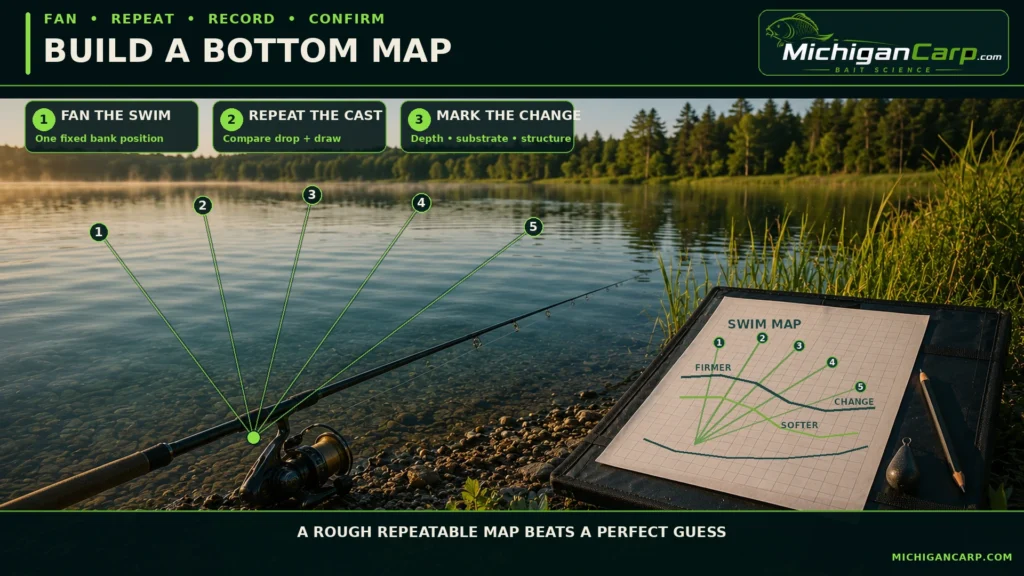
A useful swim map does not need to be pretty. It needs to let you reproduce a cast and explain what changes along it. Use one bank position, a small fan of lanes and the same lead setup. Record distance, relative or measured depth, draw, debris and the point where the signal changes.
Step 1: Fix the Casting Position
Choose a repeatable foot position or safe bank marker. Moving several feet left or right changes the line through the water and can turn the same clip distance into a different underwater path. Record the direction using a far-bank feature, compass bearing or photograph.
Step 2: Establish Distance
Use line clips and distance sticks, measured wraps, rangefinder-supported landmarks where appropriate, or another consistent system. Record the actual method. “About seventy yards” is less useful than “twenty-two wraps from the left side of the platform toward the lone pine.” Allow for safe casting and do not clip up in a way that damages line or creates an uncontrolled stop.
Step 3: Fan the Swim
Start with perhaps five lanes: far left, left-center, center, right-center and far right. Use the map or visible structure to choose sensible distances. You are not trying to grid every square yard. You are trying to discover the main contour, substrate and weed changes with the fewest casts.
Step 4: Repeat the Important Cast
When a lane produces a meaningful change, repeat it. One cast can hit a stone, branch or small weed clump. A transition that appears at the same distance twice—and preferably from a neighboring lane—is more credible.
Step 5: Mark the Change, Not Just the Spot
Record where the lead changes from chatter to smooth, suction to firm, weed to open or shallow to deep. Note the width. A transition line is easier to understand and use than a single dot that may represent one lucky landing.
| Lane | Distance | Drop or Depth | Draw | Retrieved Evidence | Interpretation |
|---|---|---|---|---|---|
| 1 — far left | 18 wraps | 8-count relative fall | Smooth, then light weed | Two green strands | Firm lane ending at weed edge |
| 2 — left-center | 20 wraps | 9-count fall | Short chatter, then smooth | Clean lead | Possible gravel-to-clay transition |
| 3 — center | 22 wraps | 11-count fall | Initial suction, heavy smooth draw | Dark fine smear | Soft silt pocket |
| 4 — right-center | 21 wraps | 10-count fall | Smooth with one sharp band | Tiny shell fragment | Firm ground crossing possible shell |
| 5 — far right | 17 wraps | 7-count fall | Springy grab and release | Dying weed | Weedy shallower section |
| Repeat lane 2 | 20 wraps | 9-count fall | Same transition at 17 wraps | Clean lead | Repeatable change worth fishing or comparing |
Use the Map During the Session
Record where rods sit, where liners occur, where fish show and where captures happen. If one lane repeatedly produces, the map helps you move another rod toward the same depth or transition without blindly copying distance. The result is a working map of carp use, not just substrate.
Confirm That Carp Actually Use the Area
Bottom mapping can identify a technically excellent presentation area. It cannot prove that carp visit it. The final confirmation comes from fish evidence: showing carp, feeding disturbance, liners, repeated timing, cleaned bait, captures or a pattern that connects the feature to season and conditions.
Watch Before and After Mapping
Observe the water before the first lead cast. Then watch how signs change. If fish stop showing after repeated mapping, the session may need quiet time. If bubbles or clouding appear on the soft edge, that evidence may outweigh the clean hard patch found ten yards away.
Distinguish Presence From Feeding
A roll confirms presence, not necessarily feeding. Tails, repeated fizzing, moving clouds, rooting behavior, persistent liners along one line and captures provide stronger evidence. Use Signs Carp Are Feeding to interpret those clues without overclaiming.
Test the Feature and Its Route
With three rods where legal and safe, one can test the mapped food area, one the transition and one the route leading to it. Keep bait and rig variables controlled enough to learn from the result. If the route rod receives liners and bites while the perfect patch stays quiet, follow the fish rather than defending the original theory.
Record Rod-Hours and Blanks
A feature that produced one fish in ten hours and then blanked for five visits is different from a seam that produces during the first hour of the same wind on repeated trips. Record effort, not just photographs. Blanks are part of the evidence if conditions and placement are also recorded.
A Polished Spot Can Be Created by Anglers
Repeated leading, baiting and fishing can clean a small area. That may create a useful presentation patch, but it does not automatically mean carp created it or prefer it. On pressured waters, a very obvious hard spot may also receive more rigs than the less tidy food area beside it.
Match Presentation to the Bottom Without Overcomplicating It
The bottom-reading article should lead to a presentation category, not duplicate every rig build. Choose the simplest safe arrangement that remains fishing on the substrate and lets you land carp. Then use the dedicated rig guides for construction details.
| Bottom Situation | Presentation Aim | Possible Direction | Safety Priority |
|---|---|---|---|
| Clean firm bottom | Hookbait and hook settle predictably | Simple bottom bait, wafter or low pop-up | Confirm no sharp shell or hidden snag crosses the line |
| Light silt over firm ground | Avoid burying the hook while keeping a natural presentation | Lighter lead, balanced bait, suitable hooklink or small PVA protection | Check the lead is not masking a deeper hazard |
| Deep soft silt | Keep hookbait available above or within the surface layer | Longer or more suitable hooklink, wafter, pop-up, helicopter/chod-style option where appropriate | Use a fish-safe lead system and avoid excessive plugging |
| Low weed or scattered debris | Protect the hook and allow the rig to settle | PVA bag/stick, pop-up or weed-suited rig | Use tackle strong enough to control fish without locking them into weed |
| Mussels, rock or sharp rubble | Prevent line failure and keep the rig clear | Abrasion-resistant leader/mainline and safer angle; consider fishing the edge | Do not sacrifice fish safety for concealment |
| Steep slope | Stop the lead and rig sliding or settling below the target | Appropriate lead shape, angle and line control | Avoid line cutting across the lip or lead rolling into snags |
| Unknown mixed bottom | Build confidence that the hook remains exposed | Simple pop-up, balanced bait or protected presentation | Recheck after a short test rather than leaving an uncertain rig all night |
Use the Simplest Rig That Solves the Actual Problem
A clean clay shelf does not demand a chod rig merely because the lake contains silt elsewhere. A deep silt pocket does not become suitable for a heavy short bottom-bait setup because that is what is already tied. Let the bottom choose the presentation family. Begin with the Carp Rig Guide for Michigan.
Use Bottom-Bait Rigs on Bottoms That Support Them
When the bottom is firm or only lightly coated, a simple hair, slipped-D, blowback-style or balanced bottom presentation can be appropriate. The Bottom-Bait Rigs guide handles those options.
Use Pop-Ups and Awkward-Ground Rigs for a Reason
A pop-up can keep the hook available over light debris or silt, while a carefully chosen helicopter or chod-style arrangement can help on deeper or less certain ground. These are problem-solving tools, not automatic upgrades. Continue with Silt, Weed and Chod-Style Carp Rigs.
Do Not Downsize Into Danger
Clear water or a clean bottom can tempt anglers toward finer line. That is the wrong response if the route crosses mussels, rocks, timber or heavy weed. The tackle must match the worst likely contact and the size of fish—not the neatness of the presentation.
Use Sonar, a Boat or a Camera as Confirmation Tools
Electronics and underwater cameras can speed up mapping and show features a lead cannot describe well. They should confirm the picture, not replace interpretation. Sonar displays acoustic returns rather than literal photographs of substrate, and settings, beam angle, bottom slope, speed and water conditions affect the result.
Use Sonar for Contour First
Depth and shape are usually the most dependable starting outputs: shelf, break, channel, hump and weed height. Mark the route and repeat the scan. A single pass can miss the side of a small feature or compress a steep slope.
Treat Hardness as a Relative Return
Official sonar guidance explains that hard bottom generally produces a stronger echo return than soft bottom. For example, Garmin describes bottom-return strength as a hardness clue, while Deeper warns that beam selection affects hardness interpretation. Compare returns with the same settings and confirm important transitions with a lead, camera or physical sample where lawful and safe.
A Boat Gives Better Angles but Adds Responsibility
From a boat, you can sound a feature vertically, inspect weed and lower a marker without long-range line drag. Wear required safety equipment, respect navigation and property rules, do not leave markers in traffic and avoid disturbing other anglers or actively feeding fish. Boat access does not make an unsafe snag fishable.
A Camera Shows a Small Window
An underwater camera can confirm weed density, shell, debris, silt surface and whether a rig lies cleanly. It is limited by clarity, light, field of view and the exact placement. Seeing no carp during a short camera drop does not prove the feature is unused. Use the camera to answer a specific question, such as “Is this firm patch covered by low weed?”
Map Data Can Be Old; Your Electronics Can Also Be Wrong
USGS inland-bathymetry guidance shows why modern surveys and integrated elevation models matter, but high-resolution coverage is not universal. Old paper charts can be outdated, while live sonar can be misread or poorly calibrated. The strongest map combines source data, field measurement and repeated fish evidence.
A Practical Michigan Field Plan and Safety Check
Michigan waters include glacial lakes, soft fertile ponds, reservoirs, drowned river channels, stump-filled dam ponds and Great Lakes-connected systems. Use one disciplined plan that works across those differences.
The Fifteen-Minute First Pass
- Watch the water and margins before casting. Note fish signs, wind, boat traffic and safe landing space.
- Check the best available contour map and record the current water level or a visible reference.
- Choose one likely area based on food, access, depth and structure—not comfort alone.
- Make a small five-lane fan with one bare lead, stopping as soon as the main pattern is clear.
- Repeat only the meaningful transition. Mark distance and direction.
- Place the first rig where fish evidence and bottom information overlap. Keep the other rods as controlled tests.
A Simple Session Record
| Field | Example |
|---|---|
| Bank and water level | South campsite bank; water 14 inches below ramp stain |
| Wind and recent change | SW 12–16 mph for 20 hours; no heavy rain |
| Lane and distance | Lane 3 toward dead pine; 21 wraps |
| Depth | Marker-float depth 11.5 ft; chart suggested 13 ft |
| Bottom sequence | Light weed → firm smooth band → soft silt at 23 wraps |
| Carp evidence | Two rolls beyond band at dusk; pin bubbles on silt edge |
| Presentation | Balanced bait on firm side; pop-up on soft side |
| Effort and result | Firm 8 rod-hours, no signs; soft edge 8 rod-hours, two liners, one carp |
| Next test | Repeat soft edge under same sustained wind before expanding bait |
Do Not Cast a Marker Into Boat or Swimmer Traffic
A marker float, braided line or repeatedly retrieved lead can create a hazard. Map only when the water is clear of swimmers, paddlers and boats, and obey property-specific rules. Stop if traffic makes the cast unsafe. Retrieve every marker and broken component.
Mussels and Snags Change the Fish-Care Standard
A shell bed, rock lip or timber line demands more than a clever rig. Use line, leader, knots and rod positioning that can withstand likely contact, and keep a safe landing route. If a carp is likely to cut off or become tethered, fish the safer edge or leave the feature alone.
Clean Gear Between Waters
Mud, weed, water and small organisms can move between venues on boats, nets, waders, buckets and marker equipment. Follow current Michigan clean-drain-dry guidance and never transport live zebra or quagga mussels. Bottom-reading tools are part of the biosecurity routine.
Robert’s Practical View
My rule is that a bottom map must improve a fishing decision. I want to know where the silt starts, where the weed ends, how the depth changes and whether carp use that line. I do not need to prove every grain of sand. On large Michigan waters, I would rather have a rough repeatable map connected to rolls, bubbles, liners and catches than a beautifully detailed hard spot with no fish. Productive soft bottom is not second class; it simply demands a presentation that suits it.
Frequently Asked Questions
What is the best bottom for carp fishing?
There is no universal best substrate. The best bottom is one carp use for food, movement or security and on which you can present and land fish safely. A productive silt edge can outperform empty gravel.
Is a hard “donk” proof of gravel?
No. It shows a strong, distinct touchdown consistent with firm ground. Clay, compact material, stone, shell and some steep surfaces can overlap. Confirm with the controlled draw, retrieved evidence and repeated casts.
Do carp feed in deep silt?
Carp can forage within soft sediment, and research confirms substantial sediment mixing in carp-access areas. Whether one deep-silt spot is productive depends on food, water conditions, fish use and whether your rig remains available.
Does foul-smelling silt mean the spot is dead?
No. Odor can indicate decomposition and reduced chemistry within sediment, but it does not prove that the overlying water lacks oxygen or that carp never feed nearby. Treat it as one clue and test presentation and fish use.
Can I measure depth by counting the lead down?
You can compare relative depth with the same setup. The count only becomes a rough depth measurement after calibration because sink rate changes with lead, line, drag, current and control of the fall. A marker float is better for an actual bank-side depth reading.
How many marker casts should I make?
As few as needed to answer the question. A five-lane fan and one or two confirmation casts often reveal the main pattern. Stop sooner when carp are present or the water is shallow and pressured.
Can sonar identify the exact bottom material?
Sonar can show depth, vegetation, structure and relative return strength. Harder bottom commonly returns a stronger signal, but settings and geometry matter. Confirm important composition claims with another method.
Should I always fish the cleanest spot?
No. Fish the spot or edge that carp use and where the presentation remains effective. Sometimes that is the clean patch; sometimes it is the soft food area beside it.
Are mussel beds good carp spots?
They can be biologically active and can create clear transitions, but they also create severe abrasion risk. Fish only with appropriate tackle and a safe line angle, or choose the less hazardous edge.
What if the bottom changes every few feet?
Describe it as mixed ground and find the most repeatable line rather than trying to label every patch. A protected or elevated hookbait can provide more confidence than forcing a bottom bait onto uncertain debris.
Does a marker float give exact depth?
It gives a practical measurement when the lead is stationary, the float rises freely and the amount of line released is measured. Deep silt, weed, slope, bow in the line and a snagged float can introduce error. Repeat it.
What is the biggest bottom-reading mistake?
Treating the hardest spot as the answer before confirming food, access and carp use. Bottom reading should connect fish to a place, not merely make the angler confident in the cast.
Next Steps
Use this guide to turn a promising part of the lake into a repeatable underwater map. Then move to the specialist article that owns the next decision:
- Reading a Lake Like a Carp Angler — choose the correct area before detailed mapping.
- How to Research New Carp Waters in Michigan — use public maps, access information and satellite clues before traveling.
- Best Depth for Carp Fishing — connect the measured contour to season and conditions.
- Weed Beds and Carp Fishing — interpret weed edges, holes, food and landing risk.
- Signs Carp Are Feeding — confirm that the mapped feature is being used.
- Carp Rig Guide for Michigan — choose the safest presentation family for the bottom.
- Silt, Weed and Chod-Style Carp Rigs — solve soft or uncertain-ground presentation problems.
Final rule: map only enough to make the next decision. Read depth, substrate and structure together; confirm the transition; then let carp evidence decide whether the feature deserves your rig.