
Michigan is full of carp water.
Some of it is obvious. Some of it is overlooked. Some of it is easy to access but not worth much effort. Some of it looks ordinary on the map but has exactly the kind of depth, food, access, and low pressure that can produce big common carp.
The problem is not finding water. The problem is sorting good carp water from water that only looks good from the road.
That is where public research tools help.
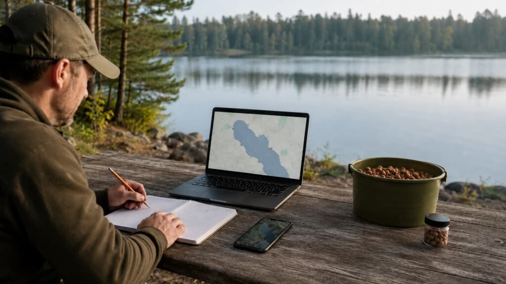
Before you load the rods, mix bait, book a campsite, or drive two hours to a lake you have never fished, you can do a surprising amount of useful work from home. You can check lake maps, public access, boat launches, Master Angler records, survey reports, satellite imagery, campground access, shoreline shape, weed growth, depth, inflows, and likely carp movement routes.
This article is not about giving away secret spots. It is about building a system.
The goal is simple: learn how to research new carp waters in Michigan using public tools, then use proper carp fishing logic to decide whether a water is worth your time.
For on-the-bank location work, pair this guide with How to Locate Carp Before You Cast, Reading a Lake Like a Carp Angler, and How to Find Carp in Big Lakes.
Why Research Matters Before You Fish
Most carp anglers waste time in one of two ways.
The first mistake is choosing water only because it is convenient. There is a lake close to home, a pier with parking, or a campground with a nice view, so that becomes the target. Sometimes that works. Often it does not.
The second mistake is choosing water only because someone once mentioned a big carp. That can be useful information, but it is not enough by itself. One photo, one rumor, or one old report does not tell you whether the fish are still there, whether you can reach them from the bank, whether the access is practical, or whether the area suits your style of fishing.
Good research gives you a better starting point.
It helps you answer questions like:
- Is there likely to be a carp population?
- Is the water big enough to grow older fish?
- Is there legal public access?
- Can I fish from the bank safely?
- Is there depth within casting range?
- Are there shallow feeding areas nearby?
- Are there inflows, marinas, bays, causeways, or weed edges?
- Is it suitable for a short session, a day session, or a multi-day campaign?
- Does the lake fit the season I plan to fish?
Research does not catch the fish for you. It simply stops you from starting blind.
Start with Access, Not Carp
The first thing to check is not whether a lake might hold carp. The first thing to check is whether you can actually fish it.
A water can look perfect on a map and still be almost useless to a bank angler. Private shoreline, steep banks, thick trees behind you, no parking, no night access, no landing area, heavy boat traffic, and awkward legal access can turn a promising carp water into a headache.
Start with public access tools.
The Michigan DNR Where to Fish page is a good starting point because it points anglers toward inland lake maps, boating access, state park fishing, and state forest campground fishing. The Michigan DNR Boating Access Sites tool can also help you locate launch areas, parking, and official access points.
Do not dismiss boat launches just because you fish from the bank. A launch can tell you a lot. It confirms public access. It shows where anglers and boaters enter the water. It often gives you clues about parking, shoreline shape, nearby bays, causeways, marinas, channels, and shallow corners.
But a boat launch is not automatically a good swim.
Ask yourself:
- Can I fish without blocking the launch?
- Is there safe room to set up rods?
- Can I land a fish without climbing rocks or fighting boat traffic?
- Is the best-looking water actually within casting range?
- Is the area too busy for quiet carp fishing?
- Are there park rules, campground rules, or local restrictions?
The best public access is not always the most obvious access. Sometimes a small state forest campground, roadside pull-off, public park, fishing pier, river access, or walk-in shoreline gives you a better carp angle than the main ramp.
For a wider look at choosing practical fishing situations, use Tactics and Watercraft & Conditions as supporting guides.
Use Michigan DNR Inland Lake Maps
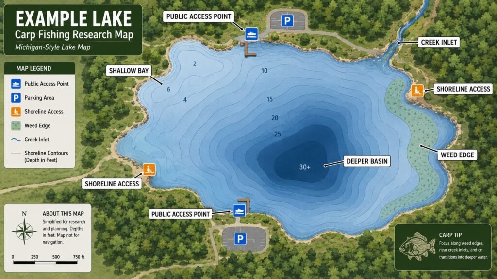
Once access looks possible, check the lake shape and depth.
The Michigan DNR Inland Lake Maps are one of the most useful public tools for carp anglers. Not every lake has a map, and older maps should not be treated as perfect, but they often give you enough information to start making sensible decisions.
When you open a lake map, do not just look for the deepest water.
Carp are not lake trout. They do not live by the deepest number on the page. What matters is how the lake is laid out.
Look for:
- shallow bays close to deeper water
- long gradual flats
- shelves and contour changes
- creek inlets and outlets
- narrow necks between basins
- inside corners
- points that push into open water
- deeper safety water near feeding shelves
- soft-bottom areas
- old river channels or basin edges
- public access close to any of the above
A lake with 30 feet of water is not automatically better than a lake with 12 feet of water. What matters is whether the carp have feeding areas, comfort water, safe routes, and enough food to support growth.
For example, a shallow bay next to a 12-foot basin may be more interesting than a deep, bowl-shaped lake with poor bank access and no obvious feeding features.
This is where your existing location knowledge matters. Use Best Depth for Carp Fishing in Michigan Lakes to think beyond numbers. Depth is useful, but transitions usually matter more than a single figure.
Look for the Right Type of Carp Water
Not every water suits the same style of carp fishing.
Some waters are good for quick evening sessions. Some are better for observation and stalking. Some only make sense as multi-day campaigns. Some are better in spring. Some are better in fall. Some are too shallow and weedy in late summer. Some are better from a boat than from the bank.
When researching a new water, try to classify it before fishing it.
A small shallow lake may warm early and produce spring action, but it may become weedy, pressured, or oxygen-sensitive in summer. A big natural lake may take longer to understand, but it may hold older fish and more stable summer habitat. A river backwater may change with flow and water level. A reservoir may have old channels, timber, snags, deep margins, and seasonal movement routes.
This is why map research should always connect to season.
Before choosing a water, ask:
- Is this a spring warming lake?
- Is it a summer weed-edge lake?
- Is it a fall feeding-route lake?
- Is it a deep-water comfort lake?
- Is it a river-connected movement water?
- Is it a campground session water?
- Is it a short-session local water?
Then match the lake to the time of year.
For the bigger seasonal picture, use the Michigan Carp Seasons Guide and the Carp Water Temperature Guide for Michigan Lakes.
Use Master Angler Records as Clues, Not Guarantees
The Michigan DNR Master Angler Program is one of the most interesting public research tools for carp anglers.
It can help you see where big fish have been reported, what counties produce larger fish, and whether certain types of water appear repeatedly. It can also reveal overlooked patterns: Great Lakes bays, connected drowned river mouths, inland lakes, reservoirs, rivers, ponds, and urban waters can all show up in different ways.
But Master Angler records need careful reading.
I have found multiple errors in master angler data so be careful and try and validate before taking anything as gospel.
A record tells you that a qualifying fish was reported. It does not tell you population density. It does not tell you how many carp are in the water. It does not tell you whether the fish was caught by rod and line, bow, spear, or another legal method unless you read the detail. It does not tell you whether the same area is practical for modern carp fishing.
Use the information as a clue, not a promise.
Good questions to ask:
- Are there repeated entries from the same water or county?
- Are entries spread across many years?
- Are fish coming from similar water types?
- Is the water connected to larger systems?
- Is there public access nearby?
- Are the fish long but lean, or genuinely heavy?
- Does the water look like it can support older carp?
- Is the reported location broad enough to protect the exact spot?
The most useful part of Master Angler research is pattern recognition.
If several large common carp appear from big connected waters, drowned river mouths, productive inland lakes, or shallow nutrient-rich systems, that tells you something. It does not mean you should chase someone else’s exact capture location. It means similar water types are worth studying.
This is also where carp anglers need restraint. Public records are public, but that does not mean every sensitive bank, campground swim, or small-water capture should be blasted online. MichiganCarp.com should encourage good research without turning every good water into a named hotspot.
Check Fishery Reports and Survey Information
The Michigan DNR Status of the Fishery Resource Reports can be useful when available. These reports are not written for carp anglers specifically, but they can still provide valuable clues.
Look for:
- fish species present
- lake productivity
- water clarity
- vegetation
- depth and basin description
- history of management
- connected waters
- public access notes
- rough fish or common carp references
- survey comments about habitat
Do not expect every report to praise carp. In many fishery-management contexts, common carp may be treated as a rough fish, a nuisance, or a species that affects vegetation and water clarity. That does not make the information useless. It simply means you need to read it as a carp angler.
If a report mentions common carp, shallow productive water, soft bottom, warm-water habitat, or abundant forage, it may be worth noting. If a report describes a sterile, very clear, low-productivity lake with poor access and limited shallow habitat, it may be less attractive for your style of fishing.
The Michigan DNR Fish Stocking Database can also help indirectly. Carp are not usually the target of stocking programs, but stocking records can tell you how actively a water is managed, what gamefish are prioritized, and whether the water receives regular angler attention.
A heavily managed trout lake may not be the best carp prospect. A warm-water lake with walleye, bass, pike, panfish, soft margins, and public access may be more interesting.
Use Satellite Imagery Like a Carp Angler
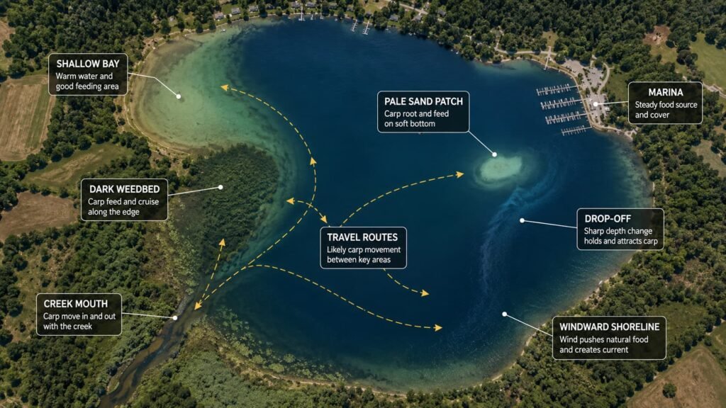
After checking official maps and access, open Google Maps or Google Earth.
Satellite imagery can reveal things a contour map will not.
Look for:
- weedbeds
- reed lines
- lily pads
- shallow flats
- color changes
- sand patches
- darker soft-bottom areas
- creek mouths
- drainage ditches
- marinas
- boat channels
- causeways
- bridges
- sheltered bays
- wind-exposed banks
- public shoreline
- campsites close to water
Do not just look at one zoom level. Start wide, then narrow down.
From a wide view, look at the lake’s overall shape. Is it round and featureless, or does it have arms, bays, points, necks, islands, and connected water? From a closer view, look at shoreline detail. Are there reeds, pads, docks, riprap, visible weed edges, shallow shelves, or small inflows?
Historical imagery can be useful where available. Some years show weed growth better than others. Some images are taken in spring before weed growth. Others show summer vegetation clearly. Water level, light angle, and clarity can change what you see.
A pale patch close to darker water might be sand, gravel, marl, or a clean feeding area. A dark strip may be weed, depth, soft bottom, or shadow. Satellite imagery gives clues, not certainty. The final truth still comes from observation, casting, leading around, sonar, or fishing.
For more on connecting visual clues to real fishing decisions, read Signs Carp Are Feeding and Reading a Lake Like a Carp Angler.
Build a Simple Water Scorecard
Once you have checked access, lake maps, public records, and satellite imagery, give the water a simple score.
You do not need anything complicated. The goal is to compare waters honestly instead of being seduced by one exciting clue.
Score each item from 0 to 3:
- Public access
- Bank fishing practicality
- Depth within casting range
- Shallow feeding areas
- Weed/reed/food habitat
- Inflows, outlets, channels, or connected water
- Evidence of carp presence
- Low pressure or overlooked areas
- Safe landing and fish care
- Suitability for your session length
A water scoring 24 out of 30 is probably worth investigating. A water scoring 12 out of 30 may still hold carp, but it might not be worth a long drive or heavy baiting campaign.
The most important score is not always carp evidence. Access can matter more. If a lake has carp but no safe public bank access, it may not suit you. If a lake has perfect access but no obvious carp habitat, it may only be a casual option. The best target waters have both: realistic carp potential and a practical way to fish them properly.
Match the Water to Your Fishing Style
Before you commit, be honest about how you actually fish.
If you are fishing short evening sessions, you need water where carp come within range quickly. That means visible signs, easy access, known feeding areas, or a regular patrol route close to the bank.
If you are fishing overnight or weekend sessions, you can choose bigger water, but you still need a reason for carp to pass your bait. Depth changes, weed edges, narrow routes, inflows, and sheltered bays matter.
If you are fishing three to five days, you can take on a more complex water, but only if access, safety, bait storage, landing space, and repeatable rod placement make sense.
If you are fishing big baits, strong tackle, and snaggy water, check whether the shoreline allows you to control fish. If the first 20 yards are full of timber, zebra mussels, rocks, or moored boats, you may need to rethink the swim. Your Line & Leaders and Rigs for Carp choices should match the water you found during research.
Do not force one style onto every lake.
Some waters suit boilies and light baiting. Some suit corn and particles. Some need single hookbaits and observation. Some need careful prebaiting. Some are best left alone until the right season.
Use the Carp Bait Guide for Michigan Lakes only after you understand the water. Bait choice should follow location, not replace it.
Plan the First Visit as a Recon Session
The first trip to a new water should not always be a full campaign.
Often, the best first visit is a recon session.
Take binoculars, polarized glasses, a notebook, phone maps, a thermometer if you have one, and just enough tackle to fish if the signs are good. Walk first. Watch the water. Look for bubbles, rolling fish, mud clouds, movement in weed, birds working over disturbed bottom, or carp cruising the margins.
Check the access you saw online. Is the bank actually fishable? Is the parking practical? Are there people swimming, boating, kayaking, or walking dogs through the swim? Is there room to cast? Can you land a fish safely? Are there snags that did not show on the map?
If you have a Deeper or castable sonar, use it carefully to confirm depth, weed, and clean spots. Do not thrash the water to pieces before you know whether fish are close. A few accurate casts can teach you more than an hour of random casting.
On the first visit, your goal is not always to catch.
Your goal is to answer:
- Did the public research match reality?
- Did I see carp or carp signs?
- Is the access safe and legal?
- Are there fishable spots within range?
- What depth and bottom did I find?
- Would I come back for a proper session?
- What season would suit this water best?
If the answer is yes, then you can build a proper plan.
Protect Good Information
Researching new carp waters is part of the fun. Protecting good information is part of being responsible.
Michigan has many public waters, but not every small carp population can handle sudden attention. Some banks are too small, some campgrounds are too exposed, and some waters have big old fish that deserve careful handling and quiet respect.
There is nothing wrong with sharing general education. There is nothing wrong with teaching people how to use public tools. There is nothing wrong with helping anglers understand lake types, access, and carp behavior.
But exact swim details, small-water captures, campground site numbers, and sensitive local knowledge should be handled carefully.
A good rule is this:
Share the system. Protect the spot.
MichiganCarp.com can help anglers become better watercraft anglers without turning every good water into a public pin.
A Simple Research Workflow
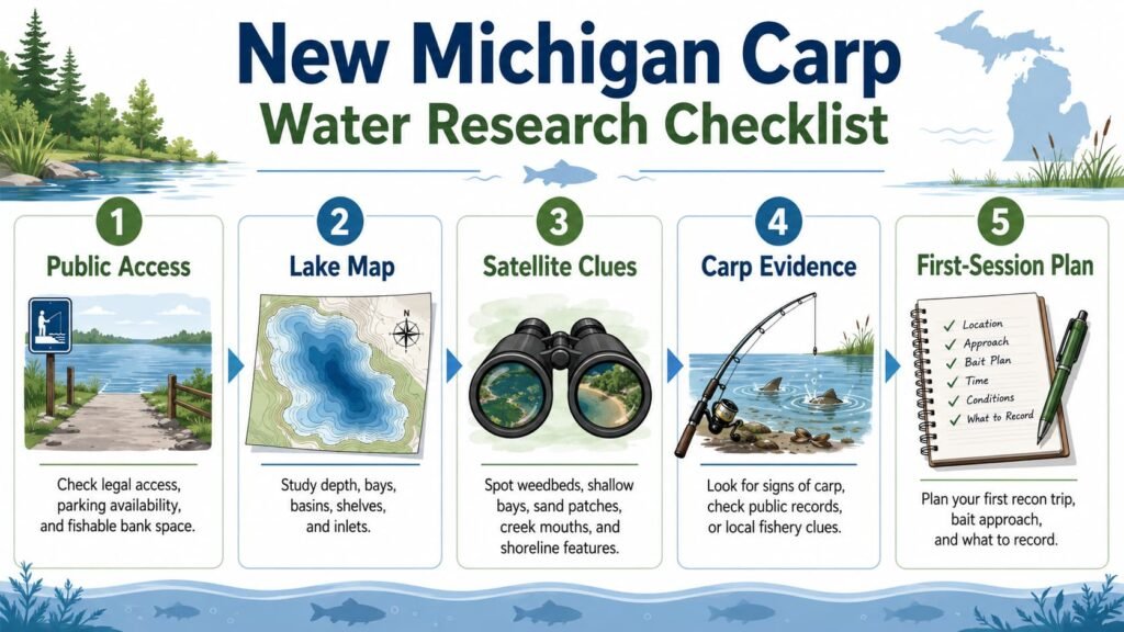
Here is a repeatable system for researching new carp waters in Michigan.
Step one: build a candidate list. Use maps, DNR resources, personal observation, campground lists, county parks, state forest areas, and public access tools.
Step two: check access. Use Michigan DNR Where to Fish, Michigan DNR Boating Access Sites, park pages, campground maps, and satellite view.
Step three: study the lake. Use Michigan DNR Inland Lake Maps and satellite imagery to find depth, bays, shelves, inlets, outlets, weed, and likely feeding areas.
Step four: check evidence. Look at the Michigan DNR Master Angler Program, fishery reports, old public reports, and visual clues. Treat all evidence as clues, not certainty.
Step five: match the season. Use Michigan Carp Seasons Guide and Carp Water Temperature Guide for Michigan Lakes to decide when the water is most likely to fish well.
Step six: plan a recon trip. Walk, watch, note access, check depth, identify safe landing areas, and only fish properly if the signs justify it.
Step seven: record what you learn. Even a blank session can be valuable if it improves your map, access notes, depth knowledge, and seasonal understanding.
Common Research Mistakes
The first mistake is chasing only big-fish rumors. Rumors can be useful, but they are not a plan.
The second mistake is choosing water from a single map. A contour map may look good, but satellite imagery may show no bank access. A launch may look easy, but the shoreline may be unfishable. A Master Angler entry may look exciting, but the water may be too busy, too private, or too difficult for your approach.
The third mistake is ignoring season. A lake that looks perfect in April may be a weed-choked mess in August. A deep clear lake that feels hopeless in spring may become more predictable in fall. A shallow weedy lake may produce well during short oxygen windows but become difficult during hot, still weather.
The fourth mistake is confusing access with location. Being able to reach the water does not mean you are fishing where carp feed.
The fifth mistake is overbaiting a new water too early. Until you know carp are present and moving through the area, keep baiting sensible. A small amount of accurate bait in the right area teaches you more than dumping a bucket into dead water.
Final Thoughts
Research will never replace watercraft, but it makes watercraft sharper.
The best carp anglers do not just turn up and hope. They narrow the search before they leave home. They use public tools, maps, access information, seasonal logic, and observation to choose better starting points.
That is especially important in Michigan because the state has so much water. Some lakes hold carp that are easy to find. Some hold carp that are rarely targeted. Some may hold old fish that move through huge areas with very little pressure. Others look promising but offer poor access, poor habitat, or very little practical opportunity.
The system is simple:
Find legal access. Study the lake. Look for carp habitat. Check public evidence. Match the season. Walk before fishing. Record what you learn. Protect sensitive information.
Do that consistently and you will waste less time, find better water, and build your own carp fishing knowledge instead of relying on guesses, rumors, or generic advice.
For the next step, read How to Locate Carp Before You Cast, How to Find Carp in Big Lakes, and Reading a Lake Like a Carp Angler.
FAQ
What is the best public tool for researching Michigan carp waters?
Start with the Michigan DNR Inland Lake Maps, then combine that with Google Maps, Google Earth, and the Michigan DNR Master Angler Program. No single tool tells the whole story.
Do Master Angler records prove a lake is worth fishing?
No. They prove that a qualifying fish was reported. That is useful, but it does not guarantee current access, good carp numbers, or a repeatable fishing pattern.
Should I publish exact locations if I find big carp?
Be careful. General education is good. Exact small-water spots, sensitive banks, campground swims, and low-pressure areas should be protected. Share the system, not every spot.
Are DNR lake maps always accurate?
They are useful starting points, but older maps and lake conditions can change. Confirm depth, weed, bottom type, and access when you visit.
What should I look for first on a new Michigan lake?
Look for legal access, safe bank fishing, shallow feeding areas close to deeper water, weed or reed edges, inflows or outlets, and signs that carp actually use the area.
Is satellite imagery enough to choose a carp swim?
No. Satellite imagery gives clues, not certainty. Use it to shortlist areas, then confirm with observation, leading around, sonar, or careful first-session fishing.